


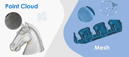
Modern technology has changed the way professionals capture and understand real-world environments. Industries such as construction, architecture, surveying, engineering, manufacturing, and mapping now rely heavily on digital methods to collect accurate spatial information. Two important technologies in this field are point cloud processing and photogrammetry.
A point cloud provides a detailed digital representation of physical objects or environments using thousands or millions of individual data points. Photogrammetry, on the other hand, uses photographs to extract measurements, shapes, and three-dimensional information from real-world subjects. Together, these technologies can make surveying and 3D modeling faster, more accurate, and easier to manage.
What Is a Point Cloud?
A point cloud is a collection of individual points that represent the shape and position of objects in three-dimensional space. Each point can contain information such as its X, Y, and Z coordinates. Depending on the scanning system, points may also include color, intensity, or other data.
Point clouds are commonly generated using LiDAR scanners, laser scanners, depth cameras, and photogrammetry software. When millions of points are collected, they can create a highly detailed digital representation of a building, road, landscape, machine, or other physical environment.
For example, a surveyor can scan a construction site and create a point cloud showing walls, floors, structural elements, terrain, and surrounding objects. This information can then be imported into specialized software for analysis and 3D modeling.
What Is Photogrammetry?
If you are wondering what is photogrammetry, it is a technique that uses photographs to obtain reliable information about physical objects and environments. Multiple images are captured from different angles, and specialized software analyzes common features between the photographs.
The software uses these shared points to determine the position and shape of objects in three-dimensional space. It can then create outputs such as 3D models, maps, measurements, and point clouds.
Photogrammetry can be performed using professional cameras, drones, smartphones, or other imaging devices. The quality of the final result depends on factors such as image resolution, camera position, lighting, image overlap, and the software used for processing.
How Does Photogrammetry Work?
The basic photogrammetry process begins with image collection. A camera captures multiple photographs of the same subject from different positions. There needs to be enough overlap between images so that software can identify matching features.
After the photographs are uploaded, photogrammetry software analyzes the images and identifies common points. These points help establish the relationship between different camera positions.
The software can then reconstruct the subject in three dimensions. Depending on the application, the final result may include a textured 3D model, digital elevation model, orthomosaic, or point cloud.
This workflow allows professionals to collect detailed information without physically measuring every part of an object or site.
Point Clouds in Surveying and Mapping
Surveying is one of the most important applications of point cloud technology. Traditional surveying methods can require significant time and manual measurements. Modern scanning systems can capture large areas much faster.
A point cloud can provide surveyors with detailed information about terrain, buildings, roads, bridges, and other structures. Once captured, the data can be analyzed to identify distances, elevations, slopes, and surface characteristics.
Drone-based photogrammetry can also produce useful mapping data over large areas. This makes the technology particularly valuable for construction sites, mining operations, agriculture, and land management.
Point Cloud vs. Traditional 3D Modeling
Traditional 3D modeling usually involves manually creating geometry based on measurements, drawings, or reference material. Although this approach remains useful, it can become time-consuming when dealing with complex environments.
Point cloud data provides a different starting point. Instead of creating everything from scratch, professionals can work with a digital representation of the existing physical environment.
For example, an architect working on the renovation of an older building can use scanning technology to capture existing conditions. The resulting point cloud can help create accurate models and identify differences between original plans and the current structure.
Benefits of Photogrammetry
Understanding what is photogrammetry also means understanding why it has become so popular across different industries. One major benefit is accessibility. Photogrammetry can often be performed with equipment that is more affordable than advanced laser scanning systems.
Another advantage is speed. A large number of photographs can be captured within a relatively short period. Software can then process these images into useful spatial data.
Photogrammetry can also capture visual information that may be valuable during inspection and documentation. When photographs contain color and texture information, the resulting 3D models can provide a realistic representation of the subject.
Combining Photogrammetry With Point Cloud Data
Photogrammetry and point cloud technology are not competing solutions in every situation. In many projects, they can work together.
Photogrammetry can generate dense point clouds from photographs, while laser scanning can capture highly accurate geometric information. Combining different data sources can provide a more complete representation of a site or object.
For example, a construction project may use laser scanning for structural measurements and drone photogrammetry for large outdoor areas. The resulting datasets can be aligned and processed within compatible software.
This combined approach can improve documentation and provide professionals with more information for decision-making.
Applications in Construction
Construction companies increasingly use 3D scanning and photogrammetry to document project progress. A site can be scanned at different stages, allowing teams to compare actual construction conditions with digital plans.
Point cloud data can help identify discrepancies, monitor structural components, and support building information modeling workflows. It can also provide a digital record of existing conditions before renovation or construction begins.
This can reduce manual measurement work and help project teams make decisions using accurate visual information.
Applications in Architecture and Engineering
Architects and engineers can use point clouds to capture existing buildings, industrial facilities, bridges, and other structures. The data can support renovation projects, inspections, design development, and documentation.
Instead of relying only on old drawings, professionals can create digital models based on the actual condition of a structure.
Photogrammetry can also be useful when capturing objects or areas that are difficult to access. Drones, for example, can collect images from elevated positions without requiring workers to physically reach every location.
The Future of 3D Data Capture
As cameras, scanners, drones, and processing software continue to improve, 3D data capture is becoming more accessible. Automated processing and artificial intelligence are also making it easier to extract useful information from large datasets.
Future workflows may combine photographs, laser scans, satellite information, and other data sources into unified digital environments. These developments could make surveying, inspection, construction planning, and asset management even more efficient.
For businesses, the ability to create accurate digital records can also improve collaboration. Teams in different locations can review the same digital data without always needing to visit the physical site.
Conclusion
Point cloud technology and photogrammetry have become important tools for capturing and understanding the physical world. A point cloud can provide detailed three-dimensional spatial information, while photogrammetry uses photographs to reconstruct objects and environments digitally.
For anyone researching what is photogrammetry, the key idea is simple: it transforms overlapping photographs into useful spatial information and 3D representations. When combined with point cloud workflows, it can support applications ranging from surveying and construction to architecture, engineering, mapping, and inspection.
As 3D technologies continue to develop, these methods will likely become an even more important part of modern digital workflows.

